Canals and Railways Attest to the Flat Earth

Curvature of the earth is never factor in by engineers, surveyors and architects when building their projects – which proves the earth is not a globe. Canals, roadways and rail tracts are always laid horizontally.

canal boat

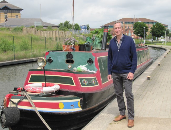
Canal boat in England

Surveyor T. Westwood wrote in 1896 stated, “In leveling, I work from Ordinance marks, or canal levels, to get the height above sea level. The puzzle to me used to be, that over several miles each level was and is treated throughout its whole length as the same level from end to end; not the least allowance being made for curvature. One of the civil engineers in this district, after some amount of argument on each side as to the reason why no allowance for curvature was made, said he did not believe anybody would know the shape of the earth in this life.”

A surveyor and engineer for 30 years wrote to Birmingham Weekly Mercury, 15 Feb., 1890 said, “I am thoroughly acquainted with the theory and practice of civil engineering. However bigoted some of our professors may be in the theory of surveying according to the prescribed rules, yet it is well known amongst us that such theoretical measurements are INCAPABLE OF ANY PRACTICAL ILLUSTRATION. All our locomotives are designed to run on what may be regarded as TRUE LEVELS or FLATS. There are, of course, partial inclines or gradients here and there, but they are always accurately defined and must be carefully traversed. But anything approaching to eight inches in the mile, increasing as the square of the distance, COULD NOT BE WORKED BY ANY ENGINE THAT WAS EVER YET CONSTRUCTED. Taking one station with another all over England and Scotland, it may be stated that all the platforms are ON THE SAME RELATIVE LEVEL. The distance between Eastern and Western coasts of England may be set down as 300 miles. If the prescribed curvature was indeed as represented, the central stations at Rugby or Warwick ought to be close upon three miles higher than a chord drawn from the two extremities. If such was the case there is not a driver or stoker within the Kingdom that would be found to take charge of the train. We can only laugh at those of your readers who seriously give us credit for such venturesome exploits, as running trains round spherical curves. Horizontal curves on levels are dangerous enough, vertical curves would be a thousand times worse, and with our rolling stock constructed as at present physically impossible.”

canal in England

Canals are built level

“As an engineer of many years standing, I saw that this absurd allowance is only permitted in school books. No engineer would dream of allowing anything of the kind. I have projected many miles of railways and many more of canals and the allowance has not even been thought of, much less allowed for. This allowance for curvature means this – that it is 8” for the first mile of a canal, and increasing at the ratio by the square of the distance in miles; thus a small navigable canal for boats, say 30 miles long, will have, by the above rule an allowance for curvature of 600 feet. Think of that and then please credit engineers as not being quite such fools. Nothing of the sort is allowed. We no more think of allowing 600 feet for a line of 30 miles of railway or canal, than of wasting our time trying to square the circle”

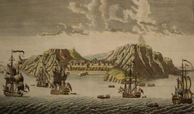
“The distance between the Red Sea at Suez and the Mediterranean Sea is 100 statute miles, the datum line of the Canal being 26 feet below the level of the Mediterranean, and is continued horizontally the whole way from sea to sea, there not being a single lock on the Canal, the surface of the water being parallel with the datum line. It is thus clear that there is no curvature or globularity for the whole hundred miles between the Mediterranean and the Red Sea; had there been, according to the Astronomic theory, the middle of the Canal would have been 1,666 feet higher than at either end, whereas the Canal is perfectly horizontal for the whole distance. The Great Canal of China, said to be 700 miles in length, was made without regard to any allowance for supposed curvature, as the Chinese believe the Earth to be a Stationary Plane. I may also add that no allowance was made for it in the North Sea Canal, or in the Manchester Ship Canal, both recently constructed, thus clearly proving that there is no globularity in Earth or Sea, so that the world cannot possibly be a Planet.” –David Wardlaw Scott, “Terra Firma”

“If the earth be the globe of popular belief, it is very evident that in cutting a canal, an allowance must be made for the curvature of the globe, which allowance would correspond to the square of the distance multiplied by eight inches. From The Age, of 5th August 1892, I extract the following: „The German Emperor performed the ceremony of opening the Gates of the Baltic and North Sea Canal, in the spring of 1891. The canal starts at Holtenau, on the south side of Kiel Bay, and joins the Elbe 15 miles above its mouth. It is 61 miles long, 200 feet wide at the surface and 85 feet at the bottom, the depth being 28 feet. No locks are required, as the surface of the two seas is level.‟ Let those who believe it is the practice for surveyors to make allowance for „curvature‟ ponder over the following from the Manchester Ship Canal Company (Earth Review, October, 1893) „It is customary in Railway and Canal constructions for all levels to be referred to a datum which is nominally horizontal and is so shown on all sections. It is not the practice in laying out Public Works to make allowances for the curvature of the earth.” –Thomas Winship, “Zetetic Cosmogeny”

Posted in Uncategorized | Tagged , | Leave a comment

Lighthouses Seen by Navigators at Far Distances

“The lights which are exhibited in lighthouses are seen by navigators at distances at which, according to the scale of the supposed „curvature‟ given by astronomers, they ought to be many hundreds of feet, in some cases, down below the line of sight! For instance: the light at Cape Hatteras is seen at such a distance (40 miles) that, according to theory, it ought to be nine-hundred feet higher above the level of the sea than it absolutely is, in order to be visible! This is a conclusive proof that there is no „curvature,‟ on the surface of the sea – „the level of the sea,‟- ridiculous though it is to be under the necessity of proving it at all: but it is, nevertheless, a conclusive proof that the Earth is not a globe.” –William Carpenter, “100 Proofs the Earth is Not a Globe”

The Isle of Wight lighthouse in England is 180 feet high and can be seen up to 42 miles away, a distance at which modern astronomers say the light should fall 996 feet below line of sight. The Cape L’Agulhas lighthouse in South Africa is 33 feet high, 238 feet above sea level, and can be seen for over 50 miles. If the world was a globe, this light would fall 1,400 feet below an observer’s line of sight! The Statue of Liberty in New York stands 326 feet above sea level and on a clear day can be seen as far as 60 miles away. If the Earth was a globe, that would put Lady Liberty at an impossible 2,074 feet below the horizon! The lighthouse at Port Said, Egypt, at an elevation of only 60 feet has been seen an astonishing 58 miles away, where, according to modern astronomy it should be 2,182 feet below the line of sight!

“The distance at which lights can be seen at sea entirely disposes of the idea that we are living on a huge ball.” –Thomas Winship, “Zetetic Cosmogeny”

“In the account of the trigonometrical operations in France, by M. M. Biot and Arago, it is stated that the light of a powerful lamp, with good reflectors, was placed on a rocky summit, in Spain, called Desierto las Palmas, and was distinctly seen from Camprey, on the Island of Iviza. The elevation of the two points was nearly the same, and the distance between them nearly 100 miles. If the earth is a globe, the light on the rock in Spain would have been more than 6600 feet, or nearly one mile and a quarter, below the line of sight.” -Dr. Samuel Rowbotham, “Zetetic Astronomy, Earth Not a Globe!”

“If we take a journey down the Chesapeake Bay, by night, we shall see the „light‟ exhibited at Sharpe’s Island for an hour before the steamer gets to it. We may take up a position on the deck so that the rail of the vessel’s side will be in a line with the „light‟ and in the line of sight; and we shall find that in the whole journey the light won’t vary in the slightest degree in its apparent elevation. But, say that a distance of thirteen miles has been traversed, the astronomers’ theory of „curvature‟ demands a difference (one way or the other!) in the apparent elevation of the light, of 112 feet 8 inches! Since, however, there is not a difference of 100 hair’s breadths, we have a plain proof that the water of the Chesapeake Bay is not curved, which is a proof that the Earth is not a globe.” -William Carpenter, “100 Proofs the Earth is Not a Globe”

“We are fairly entitled to conclude, therefore, from the reliable data furnished as to how far lights at sea can be seen, that the world is an extended plane, and not the globe of astronomical speculation.” -Thomas Winship, “Zetetic Cosmogeny”

Posted in Uncategorized | Tagged | Leave a comment

Hollyhead Pier

“The distance across St. George’s Channel, between Holyhead and Kingstown Harbour,

hollyhead pier

Hollyhead pier

near Dublin, is at least 60 statute miles. It is not an uncommon thing for passengers to notice, when in, and for a considerable distance beyond the centre of the Channel, the Light on Holyhead Pier, and the Poolbeg Light in Dublin Bay. The Lighthouse on Holyhead Pier shows a red light at an elevation of 44 feet above high water; and the Poolbeg Lighthouse exhibits two bright lights at an altitude of 68 feet; so that a vessel in the middle of the Channel would be 30 miles from each light; and allowing the observer to be on deck, and 24 feet above the water, the horizon on a globe would be 6 miles away. Deducting 6 miles from 30, the distance from the horizon to Holyhead, on the one hand, and to Dublin Bay on the other, would be 24 miles. The square of 24, multiplied by 8 inches, shows a declination of 384 feet. The altitude of the lights in Poolbeg Lighthouse is 68 feet; and of the red light on Holyhead Pier, 44 feet. Hence, if the earth were a globe, the former would always be 316 feet and the latter 340 feet below the horizon!” –Dr. Samuel Rowbotham, “Zetetic

Lighthouses Seen by Navigaors at Far Distances

“The lights which are exhibited in lighthouses are seen by navigators at distances at which, according to the scale of the supposed „curvature‟ given by astronomers, they ought to be many hundreds of feet, in some cases, down below the line of sight! For instance: the light at Cape Hatteras is seen at such a distance (40 miles) that, according to theory, it ought to be nine-hundred feet higher above the level of the sea than it absolutely is, in order to be visible! This is a conclusive proof that there is no „curvature,‟ on the surface of the sea – „the level of the sea,‟- ridiculous though it is to be under the necessity of proving it at all: but it is, nevertheless, a conclusive proof that the Earth is not a globe.” –William Carpenter, “100 Proofs the Earth is Not a Globe”

The Isle of Wight lighthouse in England is 180 feet high and can be seen up to 42 miles away, a distance at which modern astronomers say the light should fall 996 feet below line of sight. The Cape L’Agulhas lighthouse in South Africa is 33 feet high, 238 feet above sea level, and can be seen for over 50 miles. If the world was a globe, this light would fall 1,400 feet below an observer’s line of sight! The Statue of Liberty in New York stands 326 feet above sea level and on a clear day can be seen as far as 60 miles away. If the Earth was a globe, that would put Lady Liberty at an impossible 2,074 feet below the horizon! The lighthouse at Port Said, Egypt, at an elevation of only 60 feet has been seen an astonishing 58 miles away, where, according to modern astronomy it should be 2,182 feet below the line of sight!

“The distance at which lights can be seen at sea entirely disposes of the idea that we are living on a huge ball.” –Thomas Winship, “Zetetic Cosmogeny”


Posted in General Flat Earth Topics | Tagged | Leave a comment

A Wall of Water

“Astronomers are in the habit of considering two points on the Earth’s surface, without, it seems, any limit as to the distance that lies between them, as being on a level, and the intervening section, even though it be an ocean, as a vast „hill‟ – of water! The Atlantic ocean, in taking this view of the matter, would form a „hill of water‟ more than a hundred miles high! The idea is simply monstrous, and could only be entertained by scientists whose whole business is made up of materials of the same description: and it certainly requires no argument to deduce, from such „science‟ as this, a satisfactory proof that the Earth is not a globe. Every man in full command of his senses knows that a level surface is a flat or horizontal one; but astronomers tell us that the true level is the curved surface of a globe! They know that man requires a level surface on which to live, so they give him one in name which is not one in fact! This is the best that astronomers, with their theoretical science, can do for their fellow creatures – deceive them.” –William Carpenter, “100 Proofs the Earth is Not a Globe”

“Vast areas exhibit a perfectly dead level, scarcely a rise existing through 1,500 miles from the Carpathians to the Urals. South of the Baltic the country is so flat that a prevailing north wind will drive the waters of the Stattiner Haf into the mouth of the Oder, and give the river a backward flow 30 or 40 miles. The plains of Venezuela and New Granada, in South America chiefly on the left of the Orinoco, are termed Ilanos, or level fields. Often in the space of 270 square miles the surface does not vary a single foot. The Amazon only falls 12 feet in the last 700 miles of its course; the La Plata has only a descent of one thirty-third of an inch a mile.” –Rev. T. Milner, “Atlas of Physical Geography

“These extracts clearly prove that the surface of the earth is level, and that therefore the world is not a globe. And when we come to consider the surface of the world under the sea, we shall find the same uniformity of evidence against the popular view. In „Nature and Man,‟ by Professor W.B. Carpenter, article „The Deep Sea and its Contents,‟ the writer says: „If the bottom of the mid-ocean were laid dry, an observer standing on any spot of it would find himself surrounded BY A PLAIN, only comparable to that of the North American prairies or the South American pampas … The form of the depressed area which lodges the water of the deep ocean is rather, indeed, to be likened to that of a FLAT WAITER or TEA TRAY, surrounded by an elevated and deeply sloping rim, than to that of the basin with which it is commonly compared.‟ This remarkable writer tells of thousands of miles, in the Atlantic, the Pacific, and the great Southern Ocean beds being a plane surface, and from his remarks it is clear that A FLAT SURFACE IS THE GENERAL CONTOUR OF THE BED OF THE GREAT OCEANS FOR TENS OF THOUSANDS OF SQUARE MILES.” –Thomas Winship, “Zetetic Cosmogeny”

Posted in General Flat Earth Topics | Tagged | Leave a comment

Island Seen 75 Miles at Sea

St Helena Island

St Helena Island

  “In September, 1898, I received a letter from Australia in which the writer says: „In the year 1872 I was on board the ship „Thomas Wood,‟ Capt. Gibson from China to London. Owing to making a long passage, we ran short of provisions, and so short after rounding the Cape that the Captain spoke of putting into St. Helena for a supply. It was then my hobby to get the first glimpse of land, make a survey, just as the sun would be rising. The island was clearly in view, well on the starboard bow. I reported this to Capt. Gibson. He disbelieved me, saying it was impossible as we were 75 miles distant. He, however, offered me paper and pencil to sketch the land I saw. This I did. He then said, „you are right,‟ and shaped his course accordingly. I had never seen the Island before and could not have described the shape of it had I not seen it. St. Helena is a high volcanic island, and if my informant had seen the top only, there would have to be an allowance made for the height of the land, but as he sketched the island he must have seen the whole of it, which should have been 3,650 feet below the line of sight, if the world be a globe.” –Thomas Winship, “Zetetic Cosmogeny”

Posted in General Flat Earth Topics | Leave a comment

300 Foot Tower Seen 70 Miles at Sea

In the Times newspaper of Monday, Oct. 16, 1854, in an account of her Majesty’s visit to Great Grimsby from Hull, the following paragraph occurs: „Their attention was first naturally directed to a gigantic tower which rises from the center pier to the height of 300 feet, and can be seen 60 miles out at sea.‟ The 60 miles if nautical, and this is always understood when referring to distances at sea, would make 70 statute miles, to which the fall of 8 inches belongs, and as all observations at sea are considered to be made at an elevation of 10 feet above the water, for which four miles must be deducted from the whole distance, 66 statute miles will remain, the square of which multiplied by 8 inches, gives a declination towards the tower of 2,904 feet; deducting from this the altitude of the tower, 300 feet, we obtain the startling conclusion that the tower should be at the distance at which it is visible, more than 2,600 feet below the horizon!” –Dr. Samuel Rowbotham, “Earth Not a Globe, 2nd Edition”

Posted in General Flat Earth Topics | Tagged | Leave a comment

Camera Distorts Horizon

balloon-edge-space  Notice, in this photo  taken from a specially built balloon, at this altitude, the horizon should be far below the viewer AND it should be curved. This is the law of physics. Here, you see the horizon at eye level AND the horizon is flat. This means it’s a FLAT EARTH.

“The camera distorted horizons have always been a misleading factor with those who have not freed their minds from the „planet‟ or „globe earth indoctrination.‟ Three or four years ago, the U.S.I.S. booklet „Science Horizons,‟ carried a note to the effect that the Americans hoped to produce a lens which would NOT distort level horizons. So far I am not aware that such aid to truer photography has yet been made available. Flat Earthists however can prove that due to the known laws of perspective, the horizon, optically rises and remains level with the observer‟s, or the camera‟s eye, no matter what height is achieved. In fact the earth immediately beneath balloon, airplane, rocket or capsule, presents a dish-shaped or concave appearance. The point of earth immediately below the vehicle is the lowest. It is NOT the highest point of your „globe‟ earth with the dip or curvature of the „ball‟ sweeping away downwards to a horizon –Samuel Shenton, “The Plane Truth”

Level Horizon

“The marine horizon, from whatever position it is viewed, always appears to be, and is, in fact, a perfectly level line, and since this appearance is the same in all parts of the world, its surface must be level; and therefore the Earth is a Plane. This may be proved to be the case, by erecting at a suitable elevation on the sea shore, a duly-levelled board, or a string – at right angles to a plumb-line – tightly stretched between two vertical poles. On looking towards the sea, the horizontal line for a distance of 20 miles may be easily observed, and throughout its entire length it will be found to coincide with the straight-edge, or string: but if the earth were a globe, the horizontal line would form an arc of twenty miles in length, curveting both ways from the center, at the rate of eight inches, multiplied by the square of the distance. Hence the horizontal line at either end of the distance ought to be depressed some 66 feet below the horizon in the center. But as no such appearance is ever presented, it necessarily follows that the earth cannot be a globe, or other than a plane.” –B. Chas. Brough, “The Zetetic” Volume 1 Number 1, July 1872

Posted in General Flat Earth Topics | Tagged , | Leave a comment

Experience of Hot Air Ascent

19th Century hot air balloon

19th Century hot air balloon

  “The chief peculiarity of the view from a balloon at a considerable elevation was the altitude of the horizon, which remained practically on a level with the eye at an elevation of two miles, causing the surface of the earth to appear concave instead of convex, and to recede during the rapid ascent, whilst the horizon and the balloon seemed to be stationary.”

J. Glaisher wrote, “Travels in the Air,” that “On looking over the top of the car, the horizon appeared to be on a level with the eye, and taking a grand view of the whole visible area beneath, I was struck with its great regularity; all was dwarfed to one plane; it seemed too flat.” M. Victor Emanuel, another hot-air balloonist, wrote that, “Instead of the earth declining from the view on either side, and the higher part being under the car, as is popularly supposed, it was the exact opposite; the lowest part, like a huge basin, being immediately under the car, and the horizon on all sides rising to the level of the eye.” Yet another American hot-air balloonist, Mr. Elliot wrote, “The aeronaut may well be the most sceptical man about the rotundity of the earth. Philosophy forces the truth upon us; but the view of the earth from the elevation of a balloon is that of an immense terrestrial basin, the deeper part of which is directly under one‟s feet.”

“Another curious effect of the aerial ascent was, that the Earth, when we were at our greatest altitude, positively appeared concave, looking like a huge dark bowl, rather than the convex sphere such as we naturally expect to see it. The horizon always appears to be on a level with our eye, and seems to rise as we rise, until at length the elevation of the circular boundary line of the sight becomes so marked that the Earth assumes the anomalous appearance as we have said of a concave rather than a convex body.”

Posted in Uncategorized | Tagged | Leave a comment

Who ever saw a river flow up hill?

Whoever heard of a river in any part of its course flowing uphill? Yet this it would require to do were the Earth a Globe. Rivers, like the Mississippi, which flow from the North southwards towards the Equator, would need, according to Modem Astronomic theory, to run upwards, as the Earth at the Equator is said to bulge out considerably more, or, in other words, is higher than at any other part. Thus the Mississippi, in its immense course of over 3,000 miles, would have to ascend 11 miles before it reached the Gulf of Mexico!” –David Wardlaw Scott, “Terra Firma”

“There are rivers which flow east, west, north, and south – that is, rivers are flowing in all directions over the Earth’s surface, and at the same time. Now, if the Earth were a globe, some of these rivers would be flowing up-hill and others down, taking it for a fact that there really is an „up‟ and a „down‟ in nature, whatever form she assumes. But, since rivers do not flow up-hill, and the globular theory requires that they should, it is a proof that the Earth is not a globe.” –William Carpenter, “100 Proofs the Earth is Not a Globe”

Posted in General Flat Earth Topics | Tagged | Leave a comment

Architects and Engineers for Flat Earth Truth

Surveyors, engineers and architects are never required to factor the supposed curvature of the Earth into their projects, providing another proof the world is a plane, not a planet. Canals and railways, for example, are always cut and laid horizontally, often over hundreds of miles, without any allowance for curvature.

One surveyor, Mr. T. Westwood, wrote into the January, 1896 “Earth Review” magazine stating that, “In leveling, I work from Ordinance marks, or canal levels, to get the height above sea level. The puzzle to me used to be, that over several miles each level was and is treated throughout its whole length as the same level from end to end; not the least allowance being made for curvature. One of the civil engineers in this district, after some amount of argument on each side as to the reason why no allowance for curvature was made, said he did not believe anybody would know the shape of the earth in this life.”

Another Surveyor and Engineer of thirty years wrote to the Birmingham Weekly Mercury, Feb. 15th, 1890 stating, “I am thoroughly acquainted with the theory and practice of civil engineering. However bigoted some of our professors may be in the theory of surveying according to the prescribed rules, yet it is well known amongst us that such theoretical measurements are INCAPABLE OF ANY PRACTICAL ILLUSTRATION. All our locomotives are designed to run on what may be regarded as TRUE LEVELS or FLATS. There are, of course, partial inclines or gradients here and there, but they are always accurately defined and must be carefully traversed. But anything approaching to eight inches in the mile, increasing as the square of the distance, COULD NOT BE WORKED BY ANY ENGINE THAT WAS EVER YET CONSTRUCTED. Taking one station with another all over England and Scotland, it may be stated that all the platforms are ON THE SAME RELATIVE LEVEL. The distance between Eastern and Western coasts of England may be set down as 300 miles. If the prescribed curvature was indeed as represented, the central stations at Rugby or Warwick ought to be close upon three miles higher than a chord drawn from the two extremities. If such was the case there is not a driver or stoker within the Kingdom that would be found to take charge of the train. We can only laugh at those of your readers who seriously give us credit for such venturesome exploits, as running trains round spherical curves. Horizontal curves on levels are dangerous enough, vertical curves would be a thousand times worse, and with our rolling stock constructed as at present physically impossible.”

Engineer, W. Winckler, wrote into the Earth Review October 1893 regarding the Earth’s supposed curvature, stating, “As an engineer of many years standing, I saw that this absurd allowance is only permitted in school books. No engineer would dream of allowing anything of the kind. I have projected many miles of railways and many more of canals and the allowance has not even been thought of, much less allowed for. This allowance for curvature means this – that it is 8” for the first mile of a canal, and increasing at the ratio by the square of the distance in miles; thus a small navigable canal for boats, say 30 miles long, will have, by the above rule an allowance for curvature of 600 feet. Think of that and then please credit engineers as not being quite such fools. Nothing of the sort is allowed. We no more think of allowing 600 feet for a line of 30 miles of railway or canal, than of wasting our time trying to square the circle”

“If the earth be the globe of popular belief, it is very evident that in cutting a canal, an allowance must be made for the curvature of the globe, which allowance would correspond to the square of the distance multiplied by eight inches. From The Age, of 5th August 1892, I extract the following: ‘The German Emperor performed the ceremony of opening the Gates of the Baltic and North Sea Canal, in the spring of 1891. The canal starts at Holtenau, on the south side of Kiel Bay, and joins the Elbe 15 miles above its mouth. It is 61 miles long, 200 feet wide at the surface and 85 feet at the bottom, the depth being 28 feet. No locks are required, as the surface of the two seas is level.’ Let those who believe it is the practice for surveyors to make allowance for ‘curvature’ ponder over the following from the Manchester Ship Canal Company (Earth Review, October, 1893) ‘It is customary in Railway and Canal constructions for all levels to be referred to a datum which is nominally horizontal and is so shown on all sections. It is not the practice in laying out Public Works to make allowances for the curvature of the earth.” –Thomas Winship, “Zetetic Cosmogeny

The London and Northwestern Railway forms a straight line 180 miles long between London and Liverpool. The railroad’s highest point, midway at Birmingham station, is only 240 feet above sea-level. If the world were actually a globe, however, curveting 8 inches per mile squared, the 180 mile stretch of rail would form an arc with the center point at Birmingham raising a full 5,400 feet above London and Liverpool. Adding the station’s actual height (240 feet) to its theoretical inclination (5,400 feet) gives 5,640 feet as the rail’s necessary height on a globe-Earth, more than a thousand feet taller than Ben Nevis, the tallest mountain in Great Britain!

“In projecting railways on a globe, the datum line would be the arc of a circle corresponding to the latitude of the place. That the datum line for the railway projections is always a horizontal line, proves that the general configuration of the world is horizontal. To support the globe theory, the gentlemen of the observatories should call upon the surveyor to prove that he allows the necessary amount for ‘curvature.’ But this is what the learned men dare not do, as it is well-known that the allowance for the supposed curvature is never made.” –Thomas Winship, “Zetetic Cosmogeny”

“In a long line, like that of the Great Pacific Railway, extending across North America, the supposed curvature would, of course, be proportionately great, extending to many miles in height, but not one inch was allowed by the engineers for curvature during the whole course of the construction of that vast line of Railway. And, if we think of it, how could it be otherwise? All Railway metals must, of necessity, be straight, for how could any engine or carriage run with safety on a convex surface?” –David Wardlaw Scott, “Terra Firma”

Posted in Uncategorized | Tagged | Leave a comment